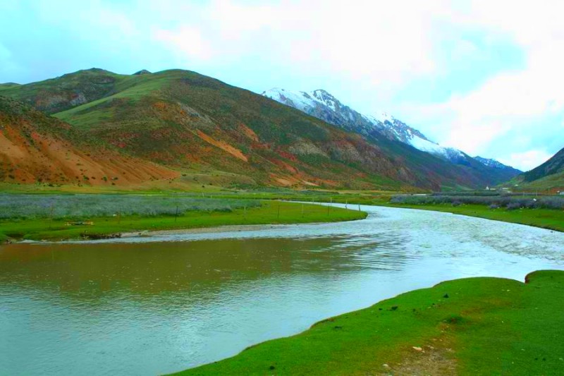
Shequ River in Qamdo

Sequ River (色曲) is the upper reach of the Duke River (杜柯河), a right-bank tributary of the Dadu River (大渡河), itself part of the Yangtze River (长江) system. In Tibetan, “Sequ” means Golden River.

The river originates from the southern foothills of the Bayan Har Mountains (巴颜喀拉山), at Qiayigangniang (恰依岗娘, elevation 4,860 m), on the border of Seda County (色达县, Sichuan Province 四川省) and Banma County (班玛县, Qinghai Province 青海省). It becomes Sequ after the confluence of Zhuri Kangduo (竹日康夺), Sewu Gully (色吾沟), Tuoru Gully (拖汝沟), and Yongla Gully (拥拉沟). Flowing southeast through central Seda County (色达县), including Huoxi Township (霍西乡) and Setang (色塘), it eventually joins the Duke River in Rangtang County (壤塘县).

The main stream is 176 km long (144 km within Seda County) with a basin area of about 3,217 km², a natural drop of 1,465 m, and an ice period lasting 5–6 months. The Sequ is mainly fed by rainfall, with snowmelt as a secondary source. Its drainage network is dendritic, with an average annual runoff of 10.5 billion m³ and a theoretical hydropower potential of 18.4 kW.

Hydrological Features

The river’s water system forms a feather-like network and provides vital irrigation for farmland. Along its banks, alluvial gold is abundant.

  • Runoff: The average annual runoff in Seda County is about 49.36 billion m³. Flow rises in May, peaks in July–September, and decreases in October, marking the dry season.
  • Sediment: The annual sediment transport reaches 526,000 tons, with the highest loads during the first two flood peaks.
  • Freezing Period: Lasting 5–6 months. From November the river begins to freeze, forming ice up to 0.7–1 m thick, strong enough for cattle and sheep to cross. Thawing occurs from March to April.

Main Tributaries

  • Cuoyi (错依): Located in Nianlong Township (年龙乡), within Selagou (色拉沟), at 4,500 m elevation, with an area of 0.015 km².
  • Cuohu (错合): Located in Luoruo Township (洛若乡), within Ziqing Gully (字清沟), at 4,300 m elevation, with an area of 0.01 km².
  • Niulaba Marshland (泥拉坝): Its Tibetan name means “Marshy Grassland.”

Development and Use

Irrigation

The Sequ flows through mixed farming and pastoral areas such as Se’erba (色尔坝). Since the 1960s, a series of irrigation canals were constructed, including Jiaxueshe, Jirishe, and others, totaling several kilometers. However, due to steep slopes, thin soil layers, and poor management, many canals eventually fell into disuse.

Drinking Water

In winter, many villages and livestock camps faced water shortages as surface water froze. From 1983 to 1990, the Seda County Water Resources Bureau built nine water-supply projects, laying over 2.6 km of pipes, benefiting 32 people and over 35,000 livestock, while also irrigating 87 mu of grassland.

Nature Conservation

In 2002, the Sequ River Provincial-Level Rare Fish Nature Reserve (色曲河州级珍稀鱼类自然保护区) was established, covering 481.7 hectares. It is divided into core, buffer, and experimental zones. The reserve primarily protects rare aquatic species such as the Chinese giant salamander, otters, and Schizothorax kozlovi, along with economic fish species like Schizothorax labiatus and Triplophysa species.

In 2022, a restocking program released 70,000 Schizothorax kozlovi and 15,000 bass carp into the river.

Travel Tips

  • Best Time to Visit: Summer (July–September) for high-water rafting and autumn for colorful landscapes. Winter showcases frozen scenery but with limited accessibility.
  • Activities: River trekking, nature photography, birdwatching, and visiting conservation areas.
  • Altitude: With headwaters at nearly 5,000 m, travelers should acclimatize properly to prevent altitude sickness.
  • Local Culture: Respect Tibetan customs in Seda (色达), especially around monasteries and villages.
  • Transport: Roads along the Sequ may be affected by seasonal floods or snow; plan ahead and check local conditions.