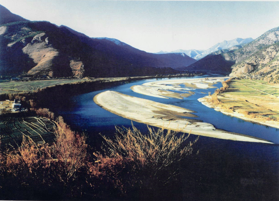
Za’gya Zangbo River in Nagqu
The Za’gya Zangbo River (扎加藏布) is the largest endorheic river (内流河) in the Tibet Autonomous Region (西藏自治区). It originates from the modern glaciers at the southern end of the Tangula Mountains (唐古拉山岗盖拉), at an altitude of 5,400 meters. Spanning a length of 480 kilometers and with a total drop of 870 meters, this river flows predominantly through high-altitude regions before draining into the Tso Kyung Lake (色林错).
Geographical Features and River Characteristics
Source and Flow
The Za’gya Zangbo River originates at an altitude of 5,400 meters and descends over its 480 kilometers, with an average slope of 1.8‰. The river basin, which has an average elevation of over 5,000 meters, showcases a terrain where the north is higher than the south, and the east is higher than the west. This asymmetric water system is shaped by tectonic faults, and its course primarily runs east to west, with occasional north to south turns due to geographical features.
River Course and Valley Sections
-
Upper Section (80 km): The upper stretch of the river spans about 80 kilometers, with a wide valley basin characterized by well-developed glacial deposits.
-
Middle Section (170 km): This section, extending 170 kilometers, features a mix of wide and narrow river valleys.
-
Lower Section (230 km): The lower stretch, approximately 230 kilometers, approaches Tso Kyung Lake, where swampy areas are visible near the lake.
River Basin Area and Water Source
The Za’gya Zangbo River has a vast basin area of 16,675 square kilometers, with its water supply primarily derived from glacial meltwater and snowmelt. This contributes to the flow of the river, which is important to the local ecosystem.
Hydrological Data and Flow Characteristics
According to a 1976 study by the Chinese Academy of Sciences (中国科学院), conducted near Zhongbao Bridge (中堡大桥) in the middle reaches of the river, the river had the following characteristics:
-
Width of the river surface: 98 meters.
-
Average flow speed: 0.35 meters per second.
-
Average water depth: 1.8 meters.
-
Flow rate: Approximately 61 cubic meters per second.
-
Mineralization level: 613 milligrams per liter.
These measurements highlight the clear and drinkable nature of the water, making it a unique resource in the region.
Climate and Ecosystem
Climate Features
The Za’gya Zangbo River flows through a cold and arid region, with low annual precipitation. The climate here is harsh and dry, typical of the Tibetan Plateau.
Ecological Resources
The river basin is home to numerous lakes, many of which are salt lakes (盐湖), contributing to the area’s rich mineral resources. It is a pure pastoral region, where the wildlife is abundant, and the plant and animal resources are valuable. The area remains a pristine natural habitat for various species of flora and fauna.
Cultural and Geographic Importance
Za’gya Zangbo’s Role in Local Life
The Za’gya Zangbo River is critical to the livelihoods of local pastoral communities. Due to its high altitude and unique characteristics, it is primarily a pastoral region where herding is the main activity. The river’s flow and the surrounding ecological system play an integral part in maintaining the sustainable lifestyle of the Tibetan people who depend on it.
The river also carries cultural significance due to its role in shaping local legends and traditions that celebrate the natural wonders of the Tibetan plateau.
The Za’gya Zangbo River (扎加藏布) is a magnificent and vital river in Tibet, offering a unique view into the geological and cultural landscapes of the Tibet Autonomous Region (西藏自治区). Its high-altitude basin, glacial origins, and diverse ecosystem make it an important natural resource and a place of deep cultural significance for the Tibetan people. Whether you’re exploring the landscape or studying the river’s ecological and hydrological data, the Za’gya Zangbo presents an awe-inspiring example of the Tibetan Plateau’s natural beauty and resilience.


