


China National Highway 219 in Tibet
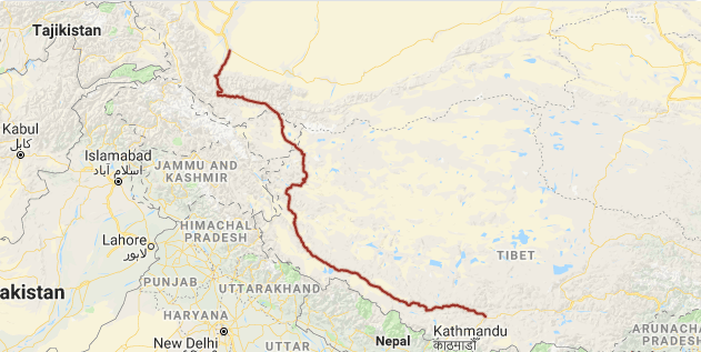 China National Highway 219 (G219) runs along the southwestern border of the People’s Republic of China, from Yecheng (Karghilik) in the Xinjiang Uyghur Autonomous Region to Lhatse in the Tibet Autonomous Region. It is 1,296 miles (2,086 kilometers) in length. Construction of this road was started in 1951. It was completed in 1957. The road passes through disputed area of Aksai Chin, an area administered by the People’s Republic of China but also claimed by India, and its construction was one of the triggers for the Sino-Indian War of 1962. Originally made of gravel, it was fully paved with asphalt in 2013.
As one of the highest motorable roads in the world, the breathtaking scenery of Rutok county also ranks as some of the most inhospitable terrain on the planet. Domar township—a town of concrete blocks and nomad tents—is one of the bleakest and most remote outposts of the People’s Liberation Army at the edge of the Aksai Chin. Near the town of Mazar many trekkers turn off for both the Karakorum range and K2 base camp. Approaching the Xinjiang border, past the final Tibetan settlement of Tserang Daban is a dangerous 5,050-meter-high pass. Tibetan nomads in the area herd both yaks and two-humped camels. Descending through the western Kunlun Shan, the road crosses additional passes of 4,000 and 3,000 meters, and the final pass offers brilliant views of the Taklamakan Desert far below before descending into the Karakax River basin. The road passes near Mount Kailash and Lake Manasarovar and Pangong Tso.
China National Highway 219
| Route information | |
|---|---|
| Length | 1,296 mi(2,086 km) |
| Existed | 1957–present |
| Major junctions | |
| north-west end | Yecheng (Karghilik) |
| south-east end | Lhatse |
| Highway system | |
| China National Highways: National Trunk Highway System & Transport in China | |
Route and Distance
| City | Distance (km) |
|---|---|
| Boxirekxiāng near Yecheng (Karghilik), Xinjiang | 0 |
| Border between Tibet Autonomous Region and Xinjiang Uyghur Autonomous Region | 705 |
| Rutog, Tibet | 936 |
| Gar, Tibet | 1063 |
| Drongpa (Zhongba), Tibet | 1640 |
| Saga, Tibet | 1794 |
| Ngamring, Tibet | 2041 |
| Chawuxiāng near Lhatse, Tibet | 2086 |


Please tell me how to travel from Yecheng County, Kashgar, to Lhasa, Tibet Autonomous Region, along the G219 route for 16-18 days in mid-late September. I have traveled alone by train and bus to North Xinjiang and South Xinjiang in March this year.
After my Tibet trip, I will return to Seoul, Korea via Xining, Qinghai Province, and the total trip period is expected to be one month.